
Tracking Water
February 10th, 2026 by RashardKelly @nasa-jpl
1 # HOLE_TO_ANOTHER_UNiVERSE########################
2 # TO#####rashardmro.tumblr.com####################
3 # ANOTHER#########################################
4 # UNiVERSE##┬─┬⃰͡ (ᵔᵕᵔ͜ )(∩`-´)⊃━☆゚.*・。゚#Hi##CORaL!
Mars Reconnaissance Orbiter : Mission Objectives NASA’s Mars Reconnaissance Orbiter searches for evidence that water persisted on the surface of Mars for a long period of time. ReadMore

Ecology-NorthAMERiCA!
Part 1 - Introduction and Demonstration of STREAM
surface water egypt link
@newshour @blackgirlscode @NASA-GISS
From hajar oukabli [1] to Everyone 12:07
would it be available to use STREAM products in spain reservoirs?
Link = https://worldview.earthdata.nasa.gov/?v=-17.455042204763462,34.75434825737002,1.8305595555240748,44.326837047762744&l=Reference_Labels_15m,Reference_Features_15m(hidden),Coastlines_15m,MODIS_Terra_L2_Chlorophyll_A,VIIRS_SNPP_L2_Chlorophyll_A,S3B_OLCI_Chlorophyll_a,S3A_OLCI_Chlorophyll_a,OCI_PACE_Chlorophyll_a,VIIRS_NOAA21_Chlorophyll_a,VIIRS_NOAA20_Chlorophyll_a,MODIS_Aqua_L2_Chlorophyll_A,Nuclear_Power_Plant_Locations,GRanD_Reservoirs,GRanD_Dams,OCI_PACE_True_Color(hidden),VIIRS_NOAA21_CorrectedReflectance_TrueColor(hidden),VIIRS_NOAA20_CorrectedReflectance_TrueColor(hidden),VIIRS_SNPP_CorrectedReflectance_TrueColor(hidden),MODIS_Aqua_CorrectedReflectance_TrueColor(hidden),MODIS_Terra_CorrectedReflectance_TrueColor&lg=true&t=2026-02-10-T19%3A28%3A10Z
LAADS DAAC primarily archives and distributes data on clouds, water vapor, and aerosols in Earth’s atmosphere as well as key instrument data for NASA, NOAA and European Space Agency missions. LAADS DAAC also serves as a backup source for MODIS and VIIRS land products. Link + Worldview @nasa @whitehouse @cityoflosangeles @la-county-isd MayorBass
om hajar oukabli to Everyone12:07 would it be available to use STREAM products in spain reservoirs? from rebwar to Everyone12:08 can this program be used for water quality of river from Sarah E. Pearce Canada to Everyone12:08 THANK YOU from Sherrie Morris to Everyone12:08 To ensure we see your question, please locate the three dots … to the bottom right of your training window. You will see a Q&A option. Place all questions there and we will answer them during the Q&A session. from Cecilia to Everyone12:09 How can I access the second section, since I did not receive the email? from Saikat Patra to Everyone12:09 thank you from rashard kelly to Everyone12:10 @ hajar oukabli #SPAiN_RESiViORS https://worldview.earthdata.nasa.gov/?v=-17.455042204763462,34.75434825737002,1.8305595555240748,44.326837047762744&l=Reference_Labels_15m,Reference_Features_15m(hidden),Coastlines_15m,MODIS_Terra_L2_Chlorophyll_A,VIIRS_SNPP_L2_Chlorophyll_A,S3B_OLCI_Chlorophyll_a,S3A_OLCI_Chlorophyll_a,OCI_PACE_Chlorophyll_a,VIIRS_NOAA21_Chlorophyll_a,VIIRS_NOAA20_Chlorophyll_a,MODIS_Aqua_L2_Chlorophyll_A,Nuclear_Power_Plant_Locations,GRanD_Reservoirs,GRanD_Dams,OCI_PACE_True_Color(hidden),VIIRS_NOAA21_CorrectedReflectance_TrueColor(hidden),VIIRS_NOAA20_CorrectedReflectance_TrueColor(hidden),VIIRS_SNPP_CorrectedReflectance_TrueColor(hidden),MODIS_Aqua_CorrectedReflectance_TrueColor(hidden),MODIS_Terra_CorrectedReflectance_TrueColor&lg=true&t=2026-02-10-T19%3A28%3A10Z from rashard kelly to Amita Mehta (privately)12:11 hajar oukabli needs the spanish resiviorss https://worldview.earthdata.nasa.gov/?v=-17.455042204763462,34.75434825737002,1.8305595555240748,44.326837047762744&l=Reference_Labels_15m,Reference_Features_15m(hidden),Coastlines_15m,MODIS_Terra_L2_Chlorophyll_A,VIIRS_SNPP_L2_Chlorophyll_A,S3B_OLCI_Chlorophyll_a,S3A_OLCI_Chlorophyll_a,OCI_PACE_Chlorophyll_a,VIIRS_NOAA21_Chlorophyll_a,VIIRS_NOAA20_Chlorophyll_a,MODIS_Aqua_L2_Chlorophyll_A,Nuclear_Power_Plant_Locations,GRanD_Reservoirs,GRanD_Dams,OCI_PACE_True_Color(hidden),VIIRS_NOAA21_CorrectedReflectance_TrueColor(hidden),VIIRS_NOAA20_CorrectedReflectance_TrueColor(hidden),VIIRS_SNPP_CorrectedReflectance_TrueColor(hidden),MODIS_Aqua_CorrectedReflectance_TrueColor(hidden),MODIS_Terra_CorrectedReflectance_TrueColor&lg=true&t=2026-02-10-T19%3A28%3A10Z from orlando.gonzalez@un.org to Everyone12:11 Is there a procedure for identifying Mercury content un land and rivers affected by gold mining? from Mishelle to Everyone12:11 for odor indicides would that not be a calculation of off gasing so particulate matter in the air quality, it could be estimated for a new data set from SYLVIE ARQUES to Everyone12:11
Latrice, i have homework, i can understand her @isro accent but still missed it doing helpdesk shit @la-county-isd MsHolly if you know latrice mom can you pass her that… i dont want to get run over! @cityoflosangeles @blackgirlscode
@newshour @blackgirlscode @NASA-GISS
from Bhupendra Sen Thakuri to Everyone11:08 Hello ! I am Bhupendra located at Brookings , South Dakota. I am an undergrad research assistant at South Dakota State University. Email: Bhupendra.SenThakuri@jacks.sdstate.edu from rebwar to Everyone11:08 hello iam from kurdistan from Vladimir Alarcon to Everyone11:09 Hi All. Here Water Quality modeler at Mississippi State University. from Taylor Josephy to Everyone11:09 Hello all - Taylor Josephy, a Watershed Geomatics Specialist with the Government of British Columbia, Canada from Francis to Everyone11:09 Hello, Francis from Ghana from Elizabeth Desser to Everyone11:09 Hi, Elizabeth Desser in Bozeman, MT USA from Elizabeth Desser to Everyone11:09 . from Sarah E. Pearce Canada to Everyone11:10 If anyone is interested in my nature, science and astronomy centre in NB, Canada for collaborations on fireflies, beaver watershed health etc please do contact me pearcesarahelizabeth@gmail.com MSc RS, MSc Astronomy from Alyssa Freedman to Everyone11:10 Hello, my name is Alyssa Freedman, and I am a Watershed Protection Specialist at Anacostia Riverkeeper in Washington, DC. from Kacper to Everyone11:10 Hello, I am Kacper Michalak, I am a GIS tech 1 and a graduate student beginning my masters in Geospatial intelligence at University of Maryland from mauricio to Everyone11:10 I checked the link, but the presentation is not avaidable from Alfonso Navarro Carvallo to Everyone11:10 Greetings for all from Peru and Chile CEO CSO and Educator in EliteSDGs Business Consulting from Christina Buffington to Everyone11:11 Hello from University of Alaska Fairbanks, Geographic Information Network of Alaska (also teach watershed management). I used to live in Helena, Montana and am familiar with Canyon Ferry Lake. Great to see it with satellite products. from Saad Arkkou to Everyone11:12 Hello everyone, I am Saad from Morocco, PhD candidate in marine sciences, specialized in hydro-sedimentary dynamics and port engineering from Natasha Johnson-Griffin to Everyone11:12 @Mauricio, are you able to try another browser? I just double checked and it opened for me in chrome. You can also try this: https://earthdata.nasa.gov/s3fs-public/2026-02/ARSET-STREAM2026-part1-slides.pdf from Jonathan Trujillo to Everyone11:13 Hello, i’m Jonathan Trujillo from México. UAV remote sensing operator, specialized in multispectral images analysis. from mauricio to Everyone11:13 Yes, this is what appears to me: The host or presenter would like Webex Meetings to open a website on your computer. Cisco is not responsible for the content or availability of external sites. We recommend that you make sure this website content is from a trusted source. If you view this page or go to this site, you will be subject to the privacy policy and terms and conditions of the destination site. Destination site: https://earthdata.nasa.gov/s3fs-public/2026-02/ARSET-STREAM2026-part1-slides.pdf from Natasha Johnson-Griffin to Everyone11:15 You will need to click ok to move forward to see the slides. from Rita to Everyone11:15 Hello from Argentina from Sarah E. Pearce Canada to Everyone11:17 i sure would from Brock Blevins to Everyone11:18 STREAM: https://ladsweb.modaps.eosdis.nasa.gov/stream/ from kenza to Everyone11:20 are these tools suitable for beginner in remote sensing?! from Natasha Johnson-Griffin to Everyone11:25 To ensure we see your question, please locate the three dots … to the bottom right of your training window. You will see a Q&A option. Place all questions there and we will answer them during the Q&A session. from Vladimir Alarcon to Everyone11:27 Here Alfred Alvarado Anderson, was not able to connect but I am attendng together with Vladimir. from rashard kelly to Everyone11:27 the filtering is awful in long beach from Bille Jean 205.154.246.88 is the external Decimal:3449484888 Hostname:lib-03-subnet-88.rdns.cenic.net ASN:2152 ISP:CENIC Services:None detected Country:United States State/Region:California City:Cypress Latitude:33.8170 (33° 49′ 1.05″ N) Longitude:-118.0373 (118° 2′ 14.25″ W) from rashard kelly to Everyone11:27 host Microsoft Windows [Version 10.0.18362.1256] (c) 2019 Microsoft Corporation. All rights reserved. C:\Users\PAC>ipconfig /all Windows IP Configuration Host Name . . . . . . . . . . . . : MPEIC26 Primary Dns Suffix . . . . . . . : lbpa.local Node Type . . . . . . . . . . . . : Hybrid IP Routing Enabled. . . . . . . . : No WINS Proxy Enabled. . . . . . . . : No DNS Suffix Search List. . . . . . : lbpa.local Ethernet adapter Ethernet: Connection-specific DNS Suffix . : Description . . . . . . . . . . . : Intel(R) Ethernet Connection (7) I219-LM Physical Address. . . . . . . . . : E4-54-E8-71-87-47 DHCP Enabled. . . . . . . . . . . : No Autoconfiguration Enabled . . . . : Yes IPv4 Address. . . . . . . . . . . : 192.168.161.126(Preferred) Subnet Mask . . . . . . . . . . . : 255.255.254.0 Default Gateway . . . . . . . . . : 192.168.160.1 DNS Servers . . . . . . . . . . . : 192.168.129.12 192.168.128.12 NetBIOS over Tcpi from Carlos Andres Rios-Franco to Everyone11:28 I’m getting “504 Gateway Time-out” from Kaden Caliendo he/him to Everyone11:28 I think all of us trying is making it time out from Kaden Caliendo he/him to Everyone11:28 I have the same thing’ from Vladimir Alarcon to Everyone11:29 Arewe going to have the video of this presentation? from Natasha Johnson-Griffin to Everyone11:29 For thos having issues with access: We will have the recording up on the training’s webpage here: https://www.earthdata.nasa.gov/learn/trainings/monitoring-water-quality-lakes-coastal-regions-using-stream within 48 hours for you to view. from Sarah E. Pearce Canada to Everyone11:32 I have a location at 296 days corner road NB, there are very small waterbodies–can I use these tools there? from Mishelle to Everyone11:32 Thank you William from Sarah E. Pearce Canada to Everyone11:32 thank you from Rayane to Everyone11:32 👏🏾 from Saad Arkkou to Everyone11:32 Thank you from Natasha Johnson-Griffin to Everyone11:32 Hello, yes you will qualify. Please allow 2 months to receive certificate via email. from Badr Nachchach to Everyone11:32 Thank you William it was clear from Anfel Benyoucef to Everyone11:32 the pdf’s link please from Ban AL Hasani to Everyone11:32 Many thanks from hajar oukabli to Everyone11:32 Thank you from William Wainwright to Everyone11:33 I’m looking into deploying more instances for STREAM to handle the traffic right now, thank you all from bakhouche wail to Everyone11:34 thanks MR .william from Amina Abi to Everyone11:35 complete beginner here , what do they man by tile list please from orlando.gonzalez@un.org to Everyone11:35 hello, everyone I am Orlando González from United Nación Office no Drugs and Crime, Colombia from rashard kelly to Everyone11:39 504 Gateway Time-out nginx The HTTP 504 Gateway Timeout server error response status code indicates that the server, while acting as a gateway or proxy, did not get a response in time from the upstream server in order to complete the request @mozilla MDN - 504 Gateway Timeout HTTP response status codes LiST @blackgirlscode @NASA-GISS @howard-university-web-services Informational responses (100 – 199) Successful responses (200 – 299) Redirection messages (300 – 399) Client error responses (400 – 499) Server error responses (500 – 599) https://ladsweb.modaps.eosdis.nasa.gov/stream/map#map=9.81/-13297027.93/4863070.84&grids=1,0 from William Wainwright to Everyone11:39 Update: STREAM should be a little more stable with the increased traffic from William Wainwright to Everyone11:40 please check again if you received any errors from Kacper to Everyone11:41 Hello, where can I find the tutorial to download QGIS and the plugins mentioned? from Natasha Johnson-Griffin to Everyone11:42 @Kacper QGIS Download and Install tutorial: https://arset.unhosting.site/course/view.php?id=29 from IsmayilZeynalov to Everyone11:42 Thank you for the invitation! from Kacper to Everyone11:42 Thank you from khiati to Everyone11:44 thank u from rashard kelly to Everyone11:45 NONDiSRUPTiVE_HELPDESK_FOR_STRANDED_STUDENTS https://archive.org/download/mars-geology-imaging-gifs_202602/VID_20260210_114125_210.mp4 from Carlos Andres Rios-Franco to Everyone11:46 I’m looking for STREAM products for Colombia, but I can’t find them. In which areas of the world is STREAM available? from Jiheon Scarlett Lee to Everyone11:46 Hello ! Everyone! My name is Jiheon Lee who is a Ph.D. candidate in Urban and environmental Engineering Dept. in South Korea. My specific research area is Climate change adaptative strategic scenario development in IWRM using watershed model and AI model in small sized basin area. My email address is urbanholic2014@gmail.com. Good to meet you all. from Shambel to Everyone11:47 Is that an average value of the ROI? from rashard kelly to Everyone11:47 tracert if u on windows traceroute if you are on linux/osx/*nix from Natasha Johnson-Griffin to Everyone11:47 To ensure we see your question, please locate the three dots … to the bottom right of your training window. You will see a Q&A option. Place all questions there and we will answer them during the Q&A session. from rashard kelly to Everyone11:47 C:\Users\PAC>tracert ladsweb.modaps.eosdis.nasa.gov Tracing route to ladsweb.modaps.eosdis.nasa.gov [198.118.194.40] over a maximum of 30 hops: 1 <1 ms <1 ms <1 ms 192.168.160.1 2 * * * Request timed out. 3 * * * Request timed out. 4 * * * Request timed out. 5 * * * Request timed out. 6 * * * Request timed out. 7 * * * Request timed out. 8 * * * Request timed out. 9 * * * Request timed out. 10 * * * Request timed out. 11 * * * Request timed out. 12 * * * Request timed out. 13 * * * Request timed out. 14 * * * Request timed out. 15 * * * Request timed out. 16 * * * Request timed out. 17 * * * Request timed out. 18 * from Natasha Johnson-Griffin to Everyone11:47 To ensure we see your question, please locate the three dots … to the bottom right of your training window. You will see a Q&A option. Place all questions there and we will answer them during the Q&A session. from rashard kelly to Everyone11:47 open the dos cmd to run tracert from Joan Dagnino Flores to Everyone11:47 Hi everyone. I’m Joan Dagnino Flores,environmental engineer from Alas Peruanas University. Email: deynos80@gmail.com from rashard kelly to Everyone11:48 Press the “Windows+R” button combination on your keyboard and type in cmd …. “cmd” from Vladimir Alarcon to Everyone11:49 Do we have the sripts available at the webssite? from Vladimir Alarcon to Everyone11:50 . from Munguleni Isaac to Everyone11:50
504 Gateway Time-out
nginx
The HTTP 504 Gateway Timeout server error response status code indicates that the server, while acting as a gateway or proxy, did not get a response in time from the upstream server in order to complete the request
- @mozilla MDN - 504 Gateway Timeout
HTTP response status codes
LiST @blackgirlscode @NASA-GISS @howard-university-web-services
Informational responses (100 – 199)
Successful responses (200 – 299)
Redirection messages (300 – 399)
Client error responses (400 – 499)
Server error responses (500 – 599)
https://ladsweb.modaps.eosdis.nasa.gov/stream/map#map=9.81/-13297027.93/4863070.84&grids=1,0
@la-county-isd @nasa-jpl @nasa-develop @nasa-giss @nasa-pds @blackgirlscode @cityoflosangeles @StateofCalifornia @nasa @Whitehouse @deptofdefense @dhs-gov @atfweb @atf-web
from Vladimir Alarcon to Everyone11:27
Here Alfred Alvarado Anderson, was not able to connect but I am attendng together with Vladimir.
from rashard kelly to Everyone11:27
the filtering is awful in long beach from Bille Jean 205.154.246.88 is the external Decimal:3449484888 Hostname:lib-03-subnet-88.rdns.cenic.net ASN:2152 ISP:CENIC Services:None detected Country:United States State/Region:California City:Cypress Latitude:33.8170 (33° 49′ 1.05″ N) Longitude:-118.0373 (118° 2′ 14.25″ W)
from rashard kelly to Everyone11:27
host Microsoft Windows [Version 10.0.18362.1256] (c) 2019 Microsoft Corporation. All rights reserved. C:\Users\PAC>ipconfig /all Windows IP Configuration Host Name . . . . . . . . . . . . : MPEIC26 Primary Dns Suffix . . . . . . . : lbpa.local Node Type . . . . . . . . . . . . : Hybrid IP Routing Enabled. . . . . . . . : No WINS Proxy Enabled. . . . . . . . : No DNS Suffix Search List. . . . . . : lbpa.local Ethernet adapter Ethernet: Connection-specific DNS Suffix . : Description . . . . . . . . . . . : Intel(R) Ethernet Connection (7) I219-LM Physical Address. . . . . . . . . : E4-54-E8-71-87-47 DHCP Enabled. . . . . . . . . . . : No Autoconfiguration Enabled . . . . : Yes IPv4 Address. . . . . . . . . . . : 192.168.161.126(Preferred) Subnet Mask . . . . . . . . . . . : 255.255.254.0 Default Gateway . . . . . . . . . : 192.168.160.1 DNS Servers . . . . . . . . . . . : 192.168.129.12 192.168.128.12 NetBIOS over Tcpi
from Carlos Andres Rios-Franco to Everyone11:28
I'm getting "504 Gateway Time-out"
from Kaden Caliendo he/him to Everyone11:28
I think all of us trying is making it time out
from Kaden Caliendo he/him to Everyone11:28
I have the same thing'
REmote Aquatic Chlorophyll-a Tracker (REACT)
This tool is designed to display the probability that aquatic chlorophyll-a > (exceeds) 10 micrograms per liter (µg/L). Probabilities are computed from aquatic reflectance from 10-meter Sentinel-2 satellite imagery.
Idaho @blackgirlscode Latrice …
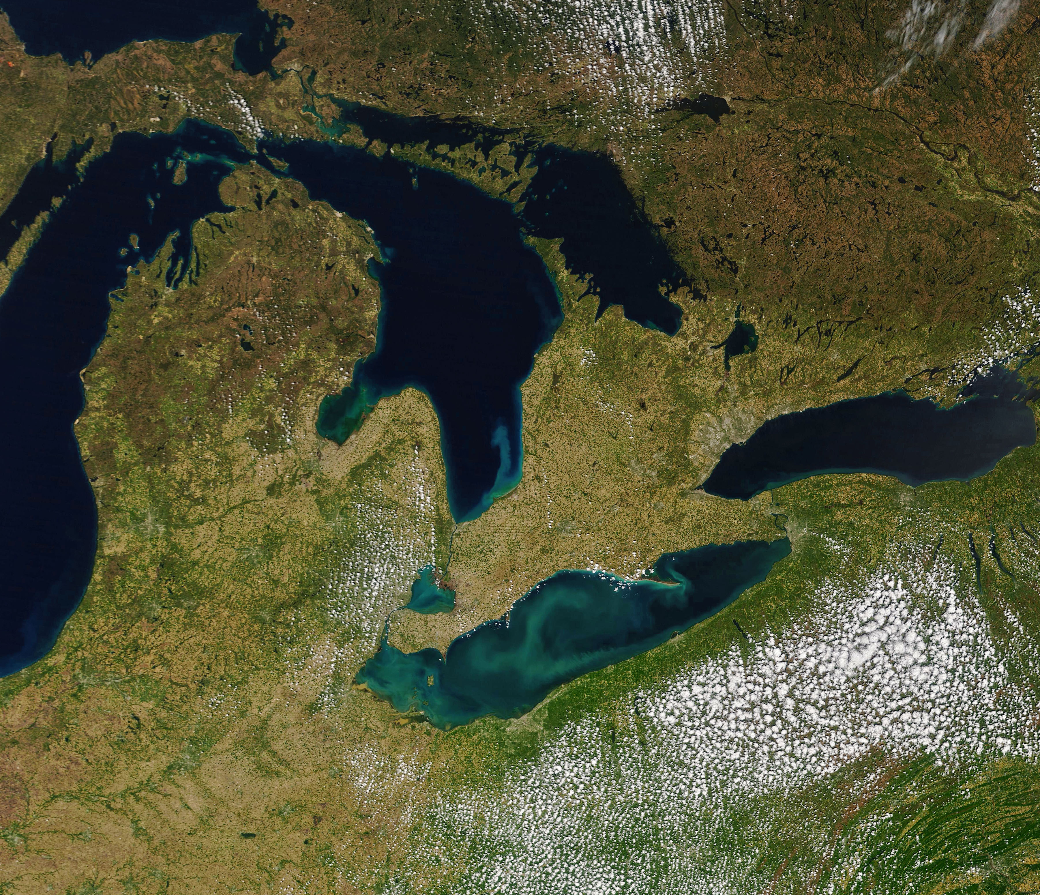
@usgs i sent my at one point girlfirends town in ohio some scans from @eu-cdse Copernicus take a look at this archive and get the .zip https://archive.org/download/2025-12-20-00-00-2025-12-20-23-59-sentinel-2-l-2-a-true-color/ohio_latrice_virtiserv_earthdata_NASA_JPL-GLENN.zip, Lake Erie while our editors mention it being Rich in quartz, limestone, and algae theres heavy deposits around Cleaveland that may need local attention ill send out an email MrsBass @nasa-jpl @nasa-pds
Laurentians
land disturbances dec20link 22
Early Holocene drought in the Laurentian Great Lakes basin caused hydrologic closure of Georgian Bay - research gate @swot-community @blackgirlscode @nasa-jpl Stream
https://mars.nasa.gov/msl-raw-images/proj/msl/redops/ods/surface/sol/04793/opgs/edr/ncam/NRB_823000360EDR_M1200574NCAM00579M.JPG_
 DECATUR Link Atlanta Government Web Tech dept @la-county-isd
NASA Glenn Research Center developed this collection of interactive simulation exercises to accompany our Beginners Guide to Aeronautics educational content @blackgirlscode READMORE
YOUNGSTOWN_HiRES_ViRTiSERV_LATRiCE - RASHARD-NASAJPL@EARTHDATA
alt=”@eu-cdse ohio looks great i the snow” @blackgirlscode
Aqua MODIS Level-3 Global Mapped Remote-Sensing Reflectance (RRS) Data, version 2022.0
Description LiNK
MODIS (or Moderate-Resolution Imaging Spectroradiometer) is a key instrument aboard the Terra (EOS AM) and Aqua (EOS PM) satellites. Terra’s orbit around the Earth is timed so that it passes from north to south across the equator in the morning, while Aqua passes south to north over the equator in the afternoon. Terra MODIS and Aqua MODIS are viewing the entire Earth’s surface every 1 to 2 days, acquiring data in 36 spectral bands, or groups of wavelengths (see MODIS Technical Specifications). These data will improve our understanding of global dynamics and processes occurring on the land, in the oceans, and in the lower atmosphere. MODIS is playing a vital role in the development of validated, global, interactive Earth system models able to predict global change accurately enough to assist policy makers in making sound decisions concerning the protection of our environment.
Time Averaged Map of Remote sensing reflectance at 547 nm (water only) monthly 4 km [MODIS-Aqua MODISA_L3m_RRS v2022.0] sr^-1 bad meets evil good shit https://www.wefunkradio.com/radio/play @blackgirlscode
Time Averaged Map of Normalized Fluorescence Line Height (water only) monthly 4 km [MODIS-Aqua MODISA_L3m_FLH v2022.0] W m^-2 um^-1 sr^-1
over 2021-Jul - 2025-Oct
EnvironmentalPages - LONGBEACH @NASA-OPENSCAPES @la-county-isd @nasa-jpl
@nasa-jpl @nasa the horizons entry for Artemis 1 has a website listed https://www.nasa.gov/artemis-1 [1] but it is forwarding to https://www.nasa.gov/images/ [nasa.gov/images/ @nasa-giss @nasa-develop @blackgirlscode @newshour @datadesk
Behind the Stripes Muna Ahmed
Read ::: OBituary
@nasa-jpl @la-county-isd @podaac @nasajpl is @uber into mars ? i dont trust them @repkarenbass @lacounty @hollyjmitchell @normani remember i got poisoned and jumped as a driver ? erika left me after maybe the ceo her pimp atmagic @uber someone tampered with your @youtube comments VideoLink @blackgirlscode ::: NORMANi - ALL_YOURS nice song
SONG - Prophet Posse … Solid Steel presents DJ Food & DK - “Now, Listen Again!” (mixed CD)
Firms FirMS - Map KML SHAPES and Archives @blackgirlscode
[Part 1: Post-Fire Imagery and Smoke Monitoring - pdf] [READ] Advanced NASA Earth Observations and Tools for Active Fire, Smoke, and Post-Fire Monitoring
NASA ARSET: Post-Fire Imagery and Smoke Monitoring Part 1/2 How Are You Making the Most of Your Imagery and Lidar? A Guide to the Power of Derivative Products watch NASA ARSET: Introduction to Satellite-Based Active Fire Detection using FIRMS, Part 1/3 watch
Hazard Mapping System Fire and Smoke Product more @noaa @nasa-jpl
The Police - Walking On The Moon (Official Music Video) watch @la-county-isd @emit-sds
 @la-county-isd
SmartLA_2028.pdf <~ @ISRO this document does not include us @USGS or @nasa-jpl and i dont know how so many of us are digitally disabled and playboy mobbed up with all the technology and we make the shit … ultimately… i dont understand capitalism mr trump @whitehouse How Will LA Look in 2028? A Look at the City’s Plan To Embrace
Transformational Tech :: Los Angeles Climate Smart Cities
TRAINING GUIDE @LAThisWeek
laincubator.org/ZERO_EMiSSiONS_ROADMAP - PDF
@CityOfLosAngeles
@la-county-isd
SmartLA_2028.pdf <~ @ISRO this document does not include us @USGS or @nasa-jpl and i dont know how so many of us are digitally disabled and playboy mobbed up with all the technology and we make the shit … ultimately… i dont understand capitalism mr trump @whitehouse How Will LA Look in 2028? A Look at the City’s Plan To Embrace
Transformational Tech :: Los Angeles Climate Smart Cities
TRAINING GUIDE @LAThisWeek
laincubator.org/ZERO_EMiSSiONS_ROADMAP - PDF
@CityOfLosAngeles
SWOT Hydrology Data Tutorials Hydrology-relevant tutorials and resources for the Surface Water and Ocean Topography (SWOT)
@Cityoflosangeles


https://eol.jsc.nasa.gov/ExplorePhotos/?mrf=ISS056-E-99699&illum=day
@NASA ARSET:
Solar Induced Chlorophyll Fluorescence (SIF) Measurements from Space Part 1/3
| Mapping surface water using Earth Engine (Floods, Water change, Seasonal Reservoirs) | Geo4Good ‘23 Surface water mapping using AI/ML Approaches of HYDRAFloods |
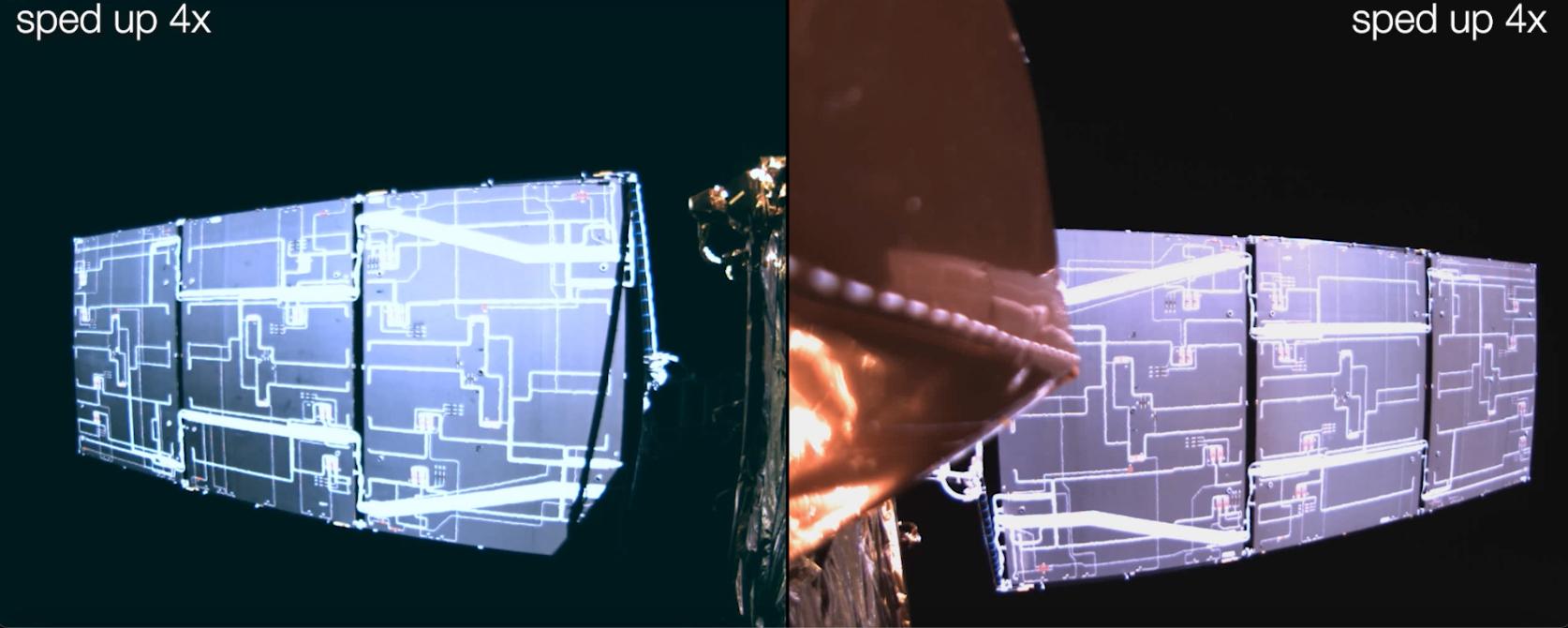
Deployment of SWOT’s Solar Arrays : WATCH READ
launched Dec. 16, 2022, at 3:46 a.m. PST from Vandenberg Space Force Base in California, and the arrays started their deployment at 5:01 a.m. PST.
NASA ARSET: Solar Induced Chlorophyll Fluorescence (SIF) Measurements from Space Part 1/3 Calendar
STREAM @cityoflosangeles @stateofcalifornia
Worldview Snapshots 4 Ersi ArcGis
Welcome
Hello world, this is my first Jekyll blog post.
I hope you like it!
Text can be bold, italic, strikethrough or keyword.
There should be whitespace between paragraphs.
There should be whitespace between paragraphs. We recommend including a README, or a file with information about your project.
Header 1
This is a normal paragraph following a header. GitHub is a code hosting platform for version control and collaboration. It lets you and others work together on projects from anywhere.
Header 2
This is a blockquote following a header.
When something is important enough, you do it even if the odds are not in your favor.
Header 3
// Javascript code with syntax highlighting.
var fun = function lang(l) {
  dateformat.i18n = require('./lang/' + l)
  return true;
}
# Ruby code with syntax highlighting
GitHubPages::Dependencies.gems.each do |gem, version|
  s.add_dependency(gem, "= #{version}")
end
Header 4
- This is an unordered list following a header.
- This is an unordered list following a header.
- This is an unordered list following a header.
Header 5
- This is an ordered list following a header.
- This is an ordered list following a header.
- This is an ordered list following a header.
Header 6
| head1 | head two | three |
|---|---|---|
| ok | good swedish fish | nice |
| out of stock | good and plenty | nice |
| ok | good oreos |
hmm |
| ok | good zoute drop |
yumm |
There’s a horizontal rule below this.
Here is an unordered list:
- Item foo
- Item bar
- Item baz
- Item zip
And an ordered list:
- Item one
- Item two
- Item three
- Item four
And a nested list:
- level 1 item
- level 2 item
- level 2 item
- level 3 item
- level 3 item
- level 1 item
- level 2 item
- level 2 item
- level 2 item
- level 1 item
- level 2 item
- level 2 item
- level 1 item
Small image
![]()
Large image

Definition lists can be used with HTML syntax.
- Name
- Godzilla
- Born
- 1952
- Birthplace
- Japan
- Color
- Green
Long, single-line code blocks should not wrap. They should horizontally scroll if they are too long. This line should be long enough to demonstrate this.
The final element.